Coastal, Rivers, and Blueways Trails
Kissimmee River Paddling Trail
All maps are printable in an 8.5 X 11" format. To print out maps in full size, please download them first to your computer before printing. For more information on mentioned boat ramps and paddle launches, please see Launch Sites and click on the icons for additional details.
Download and Print Instructions:
Maps: To print out maps in full size, please left-click on the map below to pull up the full-size map, then right-click on the full-size map and choose “Save Image As”. Save to your desktop or designated folder. Print from there.
Info Sheets: To print out Info Sheets, please click on the green Info Sheet button, then right-click on the Info Sheet and choose “Save As”. Save to your desktop or designated folder. Print from there.
KMZ: For trip planning and navigation. To download the KMZ track file, click on the KMZ button. Once downloaded, locate the file on your computer and click on it. The file will then open in Google Earth. You must have the Google Earth or Google Earth Pro app on your computer or device. KMZ routes are for general navigation purposes only and may need to be adjusted for tidal and weather considerations.
Garmin Navigation User Instructions: The downloaded KMZ file can be directly uploaded to Garmin’s Homeport or BaseCamp app (Garmin Explore app for Garmin InReach devices) and then downloaded to any Garmin GPS device.
iPhone Navigation User Instructions: https://www.floridapaddlingtrails.com/iphone-cell-phone-navigation
Android Navigation User Instructions: https://www.floridapaddlingtrails.com/android-cell-phone-navigation
Kissimmee River Paddling Trail Overview
The Kissimmee Basin encompasses more than two dozen lakes in the Kissimmee Chain of Lakes (KCOL), their tributary streams and associated marshes, and the Kissimmee River and floodplain. The basin forms the headwaters of Lake Okeechobee and the Everglades; together they comprise the Kissimmee-Okeechobee-Everglades (KOE) system.
Public use on the Kissimmee River is cooperatively managed by the Florida Fish and Wildlife Conservation Commission (FWC) and the South Florida Water Management District (SFWMD). To camp at these primitive river campsites or access them for the day, you will need a free "Special Use License" (SUL) for each campsite. Always practice “Leave No Trace” principles. Please see the links below for more SUL information. Primitive river campsites have a picnic table and fire ring.
Here is the link to the Special Use License information page: https://www.sfwmd.gov/community-residents/recreation/sul - use this for step-by-step guides for creating an account and obtaining a reservation.
If you have any issues or questions regarding the SUL's or access to SFWMD properties, just reach out to specialuselicense@sfwmd.gov.
SUL Note: When making SUL reservations, all the river campsites are listed under either Boat-In Camping or Tent camping.
Boaters planning to travel from Lake Kissimmee to Lake Okeechobee are encouraged to call ahead for navigation information. Both the Orlando and Okeechobee Service Centers can provide daily water level and navigation information. The Okeechobee Field Station can be reached at (863) 462-5280. The phone number for the Orlando Field Station is (800) 250-4200. During drought times, water levels may fall and limit access to motor boats. Also, periodic maintenance and Kissimmee River Restoration project construction may restrict navigation. During periods of high water, some river campsites may be flooded.
Safety Note: This is airboat country! It is highly recommended that all paddlecraft display a 6 to 10 foot high flag on their vessel due to limited visibility in the high marsh grass. Avoid paddling close to the shore, especially during alligator nesting season.
Lock Information: Weekday Hours for Locks S-65, S-65A, S-65D, S-65E Monday – Friday, all year, 7:00 a.m. – 6:00 p.m.
Weekend Hours for Locks S-65, S-65A, S-65D, S-65E March 1 – October 31, 5:30 a.m. – 7:30 p.m. November 1 – February 28, 5:30 a.m. – 6:30 p.m. Approximate time it takes to go through locks is 15 minutes. There is no charge for going through locks during posted hours. After hours, however, the locktender is not required to permit passage. If boats are admitted, a fee may be charged. For your own protection, and as a courtesy, notify the locktender ahead of time if late passage is necessary. Heading south, the first two locks, S65 and S65A are on river right, and the last two locks, S65D and S65E are on river left. When approaching the locks, pull the cord to alert the locktender, and await for his signal to proceed into the lock. Once in the lock, hold on to the ropes hanging down the sides, while the second gate is slowly opened, lowering the water level until it matches the level of downstream side of the lock. Once that is done, the lock will open all the way. Stay, holding on to the rope, until the locktender tells you to exit.
Water Levels: The Kissimmee River generally starts to overflow its banks when the cfs exceeds 1,400 at S65A. The river is best paddled when the cfs at S65A is below 5,000 cfs, when river campsites are more likely to be dry. Although the birding and wildlife viewing is exceptional at any water level on the Kissimmee River, it is truly spectacular when the river is within its banks. “Go to this link to find the latest river stage and flow data from the US Army Corps of Engineers https://w3.saj.usace.army.mil/h2o/reports/r-kss.html, or here for data from the SFWMD https://apps.sfwmd.gov/sitestatus/#/lower-kiss”
Restoration: The Kissimmee River once meandered for 103 miles through central Florida. Its floodplain, reaching up to 3 miles wide, was inundated for long periods by heavy seasonal rains. Native wetland plants, wading birds, and fish thrived there, but prolonged flooding in 1947 prompted a public outcry for federal assistance to reduce flood damage to property. In 1948, the U.S. Congress authorized the U.S. Army Corps of Engineers to construct the Central and South Florida Project, which led to engineering changes to deepen, straighten and widen the waterway.
In the 1960s, the Kissimmee River was channelized by cutting and dredging a 30-foot-deep straightaway through the river's meanders: the C-38 canal. Before channelization was complete, biologists suspected the project would have devastating ecological consequences. While the project delivered on the promise of flood protection, it also destroyed much of a floodplain-dependent ecosystem that nurtured threatened and endangered species, as well as hundreds of other native fish and wetland-dependent animals. More than 90 percent of the waterfowl that once graced the wetlands disappeared and the number of bald eagle nesting territories decreased by 70 percent. After the waterway was transformed into a straight, deep canal, it became oxygen-depleted and the fish community it supported changed dramatically.
After extensive planning, construction for the Kissimmee River Restoration Project began in 1999 with backfilling 8 miles of the C-38 canal. Three construction phases are now complete, and continuous water flow has been re-established to 24 miles of the meandering Kissimmee River. Seasonal rains and flows now inundate the floodplain in the restored area.
The South Florida Water Management District (SFWMD) and the U.S. Army Corps of Engineers Jacksonville District (USACE) hosted a ribbon-cutting event to celebrate the completion of the construction for the Kissimmee River Restoration Project in July 2021. The Kissimmee River Restoration Project restores more than 40 square miles of the river floodplain ecosystem, 20,000 acres of wetlands, and 44 miles of the historic river channel. This major restoration effort is a 50-50 partnership between the USACE and the SFWMD. Over the past 22 years, the USACE and SFWMD worked together to:
Complete backfilling of 22-miles of the C-38 canal between Lakes Kissimmee and Okeechobee.
Reconstruct remnant river channels across the backfilled canal to reconnect and restore flow in remnant river channels.
Remove two water control structures.
Add two gates to the S-65 water control structure.
Acquire more than 100,000 acres of land to restore the river and floodplain.

Snail Kite with Snail


Mottled Ducks (Non-Migratory)
Flora/Fauna: Since the river’s restoration, the Kissimmee River basin has once again become a great bird watching mecca. Water birds include a variety of herons, cranes, storks, egrets, white and glossy ibises, stilts, limpkins, raptors, snail kites, cormorants, anhingas, and native waterfowl as well as non-resident, migratory waterfowl in the winter months. Other common wildlife includes the Florida alligator, turtles, eagles, osprey, and vultures.
Water flora includes spatterdock, duckweed, button bush, duck potato, pickerel weed, alligator flag, cattails, sawgrass, soft rush, and water spangles. Nuisance exotic vegetation may also be observed such as water lettuce, water hyacinth, Cuban bulrush, and West Indian marsh grass.
River Campsites: All river campsites require a Special Use License (SUL) from the South Florida Water Management District. Boat-in campsites are limited to 6 campers.
Supplies: Except before the last campsite (S65E) at the Kissimmee River Fishing Resort Store, food and water are not available along the river, so you will need to carry all food and water. If you cannot carry enough water, an appropriate portable water purifier is an option worth considering.
Emergency Numbers:
Police, Fire and Medical Emergencies: 911
Florida Fish & Wildlife Commission Hotline: 1-888-404-3922
Polk County Sheriff: 863-298-6200
Osceola County Sheriff: 407-348-1100
Highlands County Sherriff: 863 402-7200
Okeechobee County Sherriff: 863-763-3117
Kissimmee River Paddling Trail Story Map by Doug Alderson: https://storymaps.arcgis.com/stories/12c12f22305048f19132048527a95751
Live Wildly ArticleWords and photography by Doug Alderson
Author of New Dawn for the Kissimmee River (University Press of Florida, 2009): Return to the Kissimmee River: Restored Historic Waterway is Now Open to Paddlers - Live Wildly
Parking:
Contact the Manager at Shady Oaks Rec Area Colemans Landing, located at the south end of Lake Kissimmee for camping and overnight parking at the trails beginning.
There is now trails end overnight parking allowed at C Scott Driver County ramp. A Permit and Liability Waiver is required. Contact Okeechobee County Parks and Recreation (863) 763-6950.
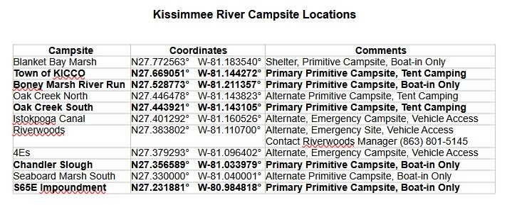
Recommended Campsites in Bold
Note: At low water levels, access to the Boney Marsh River Run Campsite may require crossing a small sandbar in the side creek that leads up to the landing. Please follow all the KMZ trails posted and be aware that the river is constantly changing.
Distances Between All River Campsites
Shady Oaks Rec Area – Coleman Landing to Blanket Bay Marsh Shelter/Campsite 4.75 Miles
Blanket Bay Marsh Shelter/Campsite to Town of KICCO Campsite 7.65 Miles
Town of KICCO Campsite to Boney Marsh River Run Campsite 15.6 Miles
Boney Marsh River Run Campsite to Oak Creek North Campsite 11 Miles
Oak Creek North Campsite to Oak Creek South Campsite .2 Miles
Oak Creek South to Riverwoods 7.7 Miles
Riverwoods to 4Es Campsite 1.0 Miles
4Es Campsite to Chandler Slough Campsite 6.8 Miles
Chandler Slough Campsite to Seaboard Marsh South Campsite 3.25 Miles
Seaboard Marsh South Campsite to S65E Impoundment Campsite 10.75 Miles
S65E Impoundment Campsite to C Scott Driver Park 10.2 Miles
TOTAL: 78.7 Miles